|
Click on an
image to enlarge it
Hydrogeological interpretation of
some Nazca
Lines along the South Bank
of Rio Ingenio
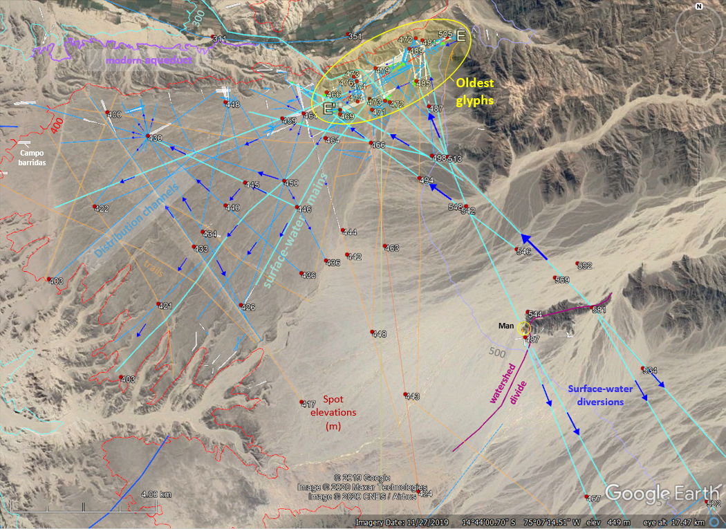
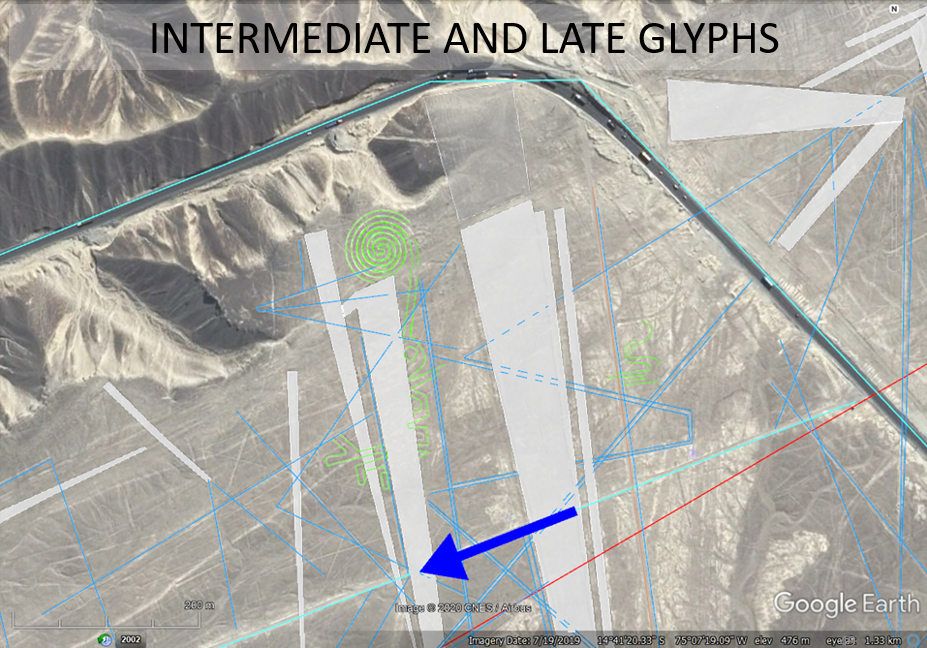
Figure 1. Captured GE display of
Nazca lines from a hydrogeological perspective including surface-water-diversion
elements, trails and hypsography. The oldest glyphs
are located high along the south bank of Rio Ingenio where
groundwater seepage naturally occurred because of the hydrogeological framework . The lines are water circuits that
divert stream flow
downgrade and across the pampas for field irrigation. The
oldest glyphs are cross-cut and overprinted by younger water mains and distribution
circuits.
South view of the Nazca aquifer along the South Bank
of Rio Ingenio highlighting a modern aqueduct.
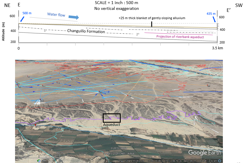
Figure 2.
The top diagram is a hydrogeological profile
of the Nazca aquifer showing surficial and bedrock aquifer
components. The middle figure is a captured GE display of the aquifer
from an oblique view looking Southeast that shows the perched nature of
the Nazca aquifer sitting above active valley farms and a modern
aqueduct (bottom GE figure).
Tectonic setting and the Nazca Impact Craters
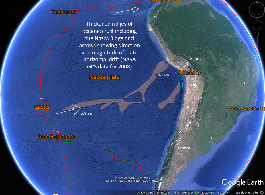
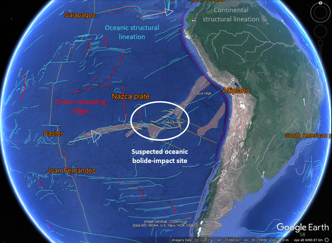
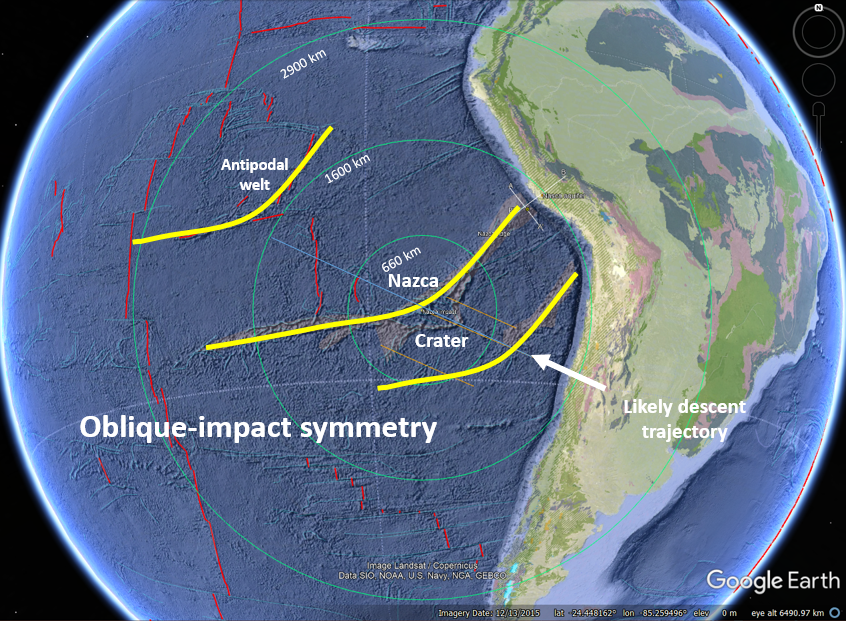
Figure
5. Captured GE displays of the suspected Nazca
impact crater (~23 Ma) and associated East-Pacific Rise, Nazca Ridge(s),
far-field lithospheric welts, tectonics plates,
and volcanoes. The oblique impact came in from the ESE and imparted deeply
penetrating and widespread fracture systems that helped shape the East
Pacific region.
Table 1. Names, geographic
coordinates and diameters of two of the larger, suspected craters associated with the Nazca
impact event.
Crater Longitude
(dd) Latitude (dd) Diameter (km)
Nazca-1 170.817829
19.056199
60
Nazca-2 171.412033
19.828540
80
Regional geological map and cross sections
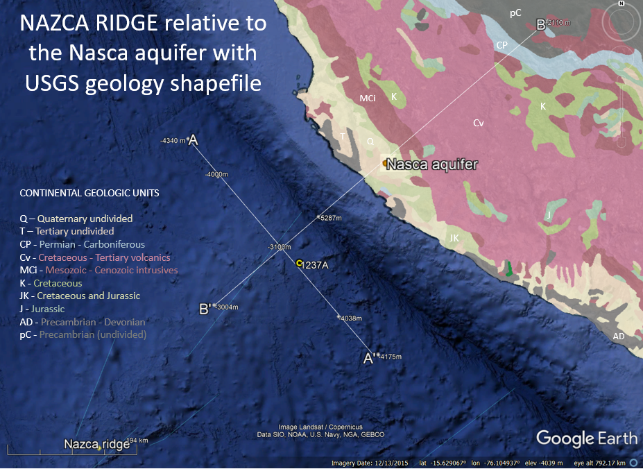
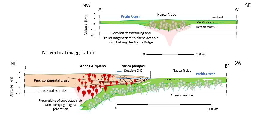
Figure 6.
GE captured views (top and middle) and
corresponding regional tectonic profiles (bottom) across the Nazca Ridge
and continental margin.
Geological setting and cross sections
through
part of the Rio Grande drainage 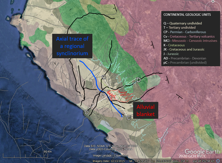
Figure
7.
GE display of U.S. Geological Survey geology theme showing
a trace of regional synclinorium, the alluvial blanket hosting the Nazca
aquifer, and the Rio Grande fault-system interpretation.
Geological cross sections across the depresión de Ica-Nasca (fig. 11)
illustrating how bedrock is gently titled by normal faulting atop a
structural culmination.
Nazca aquifer surficial and bedrock elements
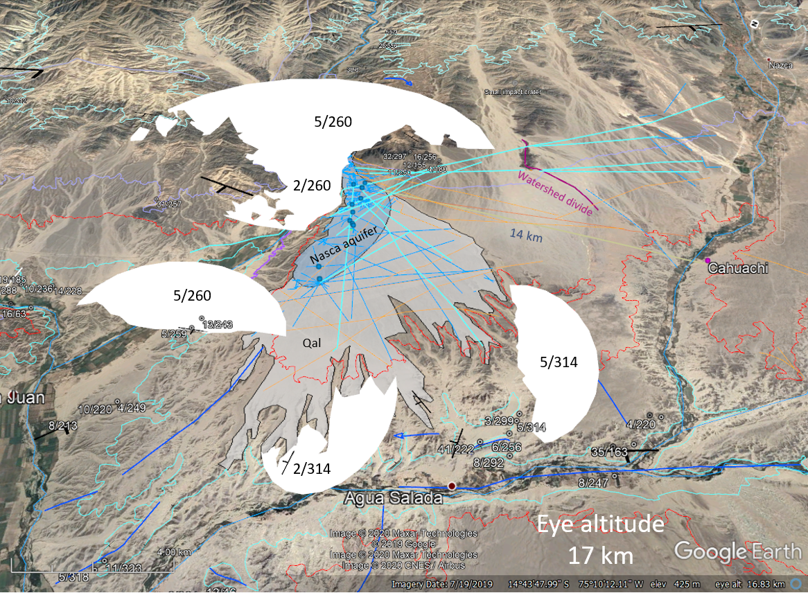
Figure 8. The Nazca aquifer has both
surficial and bedrock components. The bedrock is gently tilted to direct
flows downslope to the south bank of Rio Ingenio where thick alluvium
occurs. The blue lines are traces of open, synclinal (V) fold axes.
Dip/strike values noted on 3D white ellipses.
Nazca Lines structural setting and bedrock stratigraphy of the Tertiary
Changuillo Formation
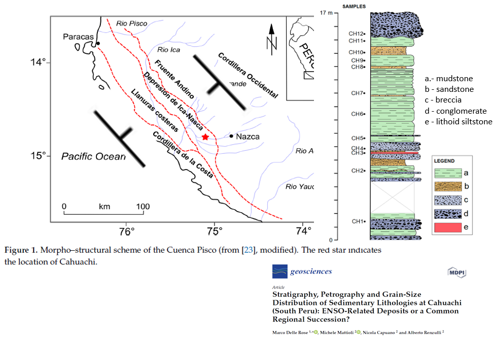 Figure 9. Morpho-structural map and
a representative bedrock section from Delle Rose and others
(2019) . Note how the depresion de Ica-Nasca is the keel of regional
synclinorium.
Figure 9. Morpho-structural map and
a representative bedrock section from Delle Rose and others
(2019) . Note how the depresion de Ica-Nasca is the keel of regional
synclinorium.
Nazca 1:100:000 scale stratigraphy
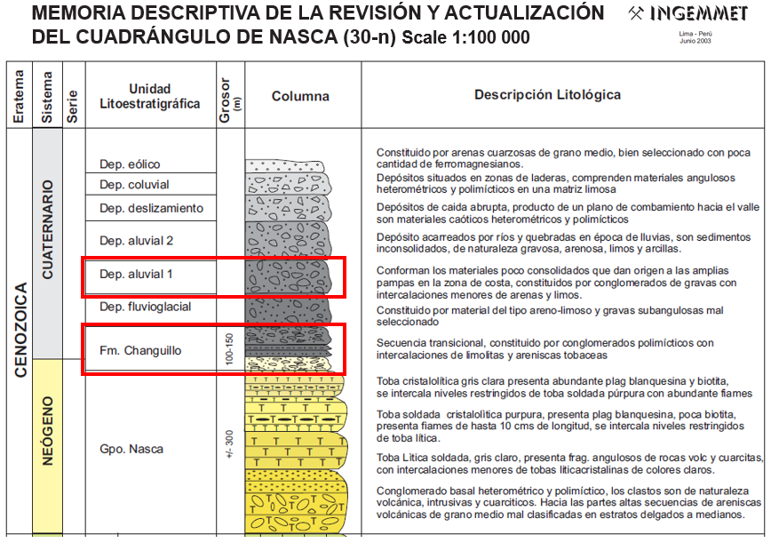
Figure 10. 1:100,000-scale geological
mapping includes a stratigraphic column showing the two principle units
comprising the Nazca aquifer (Wetzell and Matos, 2003).
The geoglyphs are ‘earth markings’ in the
form of shallow trenches or raised berms and mounds with up to 60 cm
relief and large areas cleared of soil and stones.
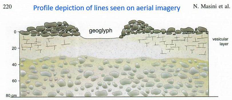
Figure 11. Profile depiction of a
Nazca line by Masini and others (2016).
Timeline of some pre-Columbian human-cultural periods, complexes, and traditions
with respect to Holocene global temperature
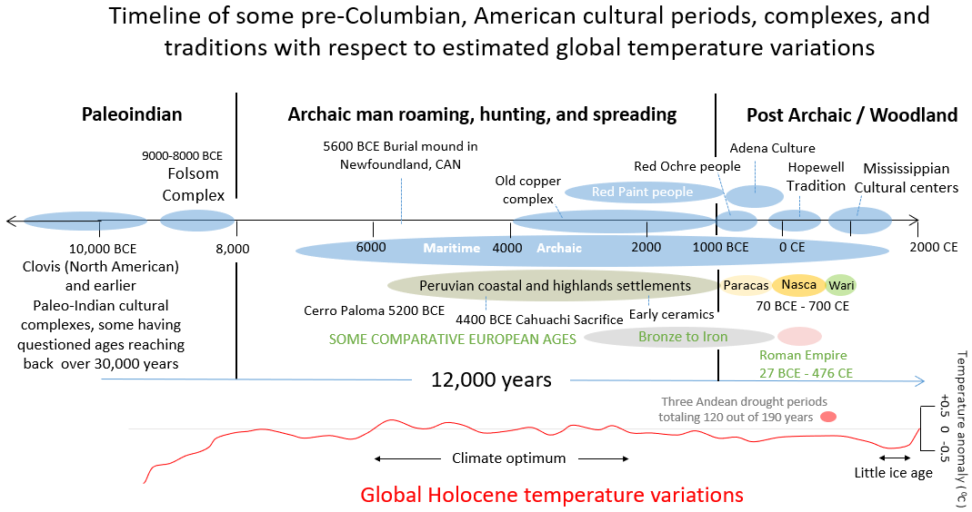
Figure 12.The Nasca culture falls into a time when human social communities and networks were
proliferating worldwide but subject to local environmental constraints
and global climate change.
Nasca Art temporal and thematic categories
 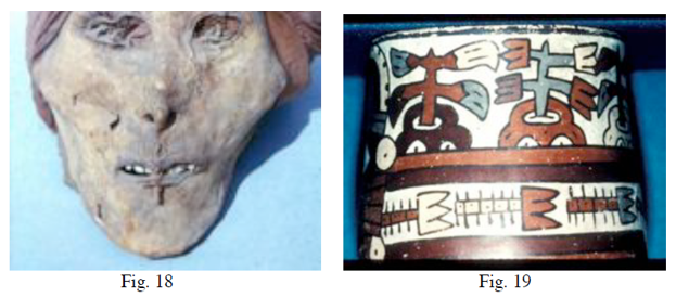
Figure 13.
The Nasca art
defines early, middle, and late cultural stages depicted first by
naturalistic motifs, followed by agrarian and religious ones, and
culminating with militaristic themes with many human trophy heads
symbolically (?) serving as planters (from Proulx's
Nasca iconography and
ritual-heads website).
Ocean-Drilling Program Site 1236 Coring results
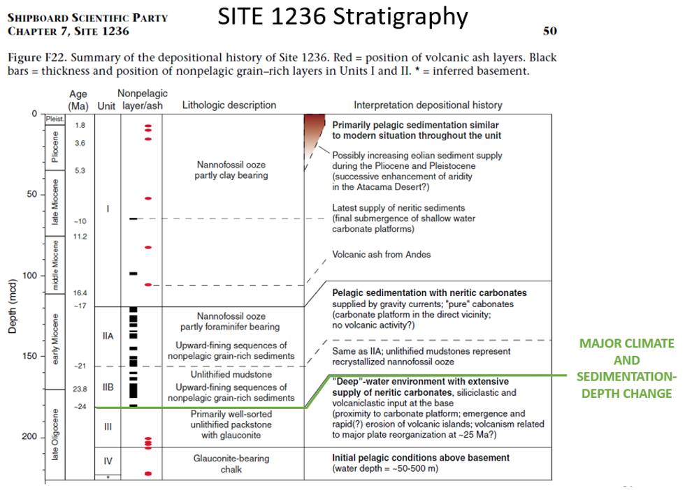
Figure 15. Major climatic and
sedimentation changes occur in the stratigraphic record of the Nazca
Ridge at
~24 Ma, the suspected age of the Nazca impact crater.
Nazca aquifer model extent (left) and
water-diversion circuits
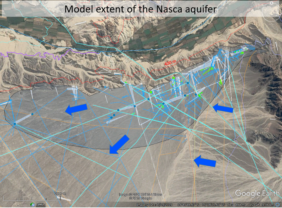
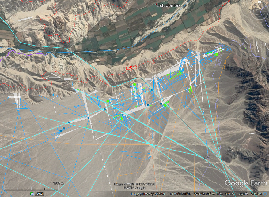
Figure 16. Geospatial elements
and fresh-water flow directions in the Nazca aquifer
Starburst geoglyph hydrology
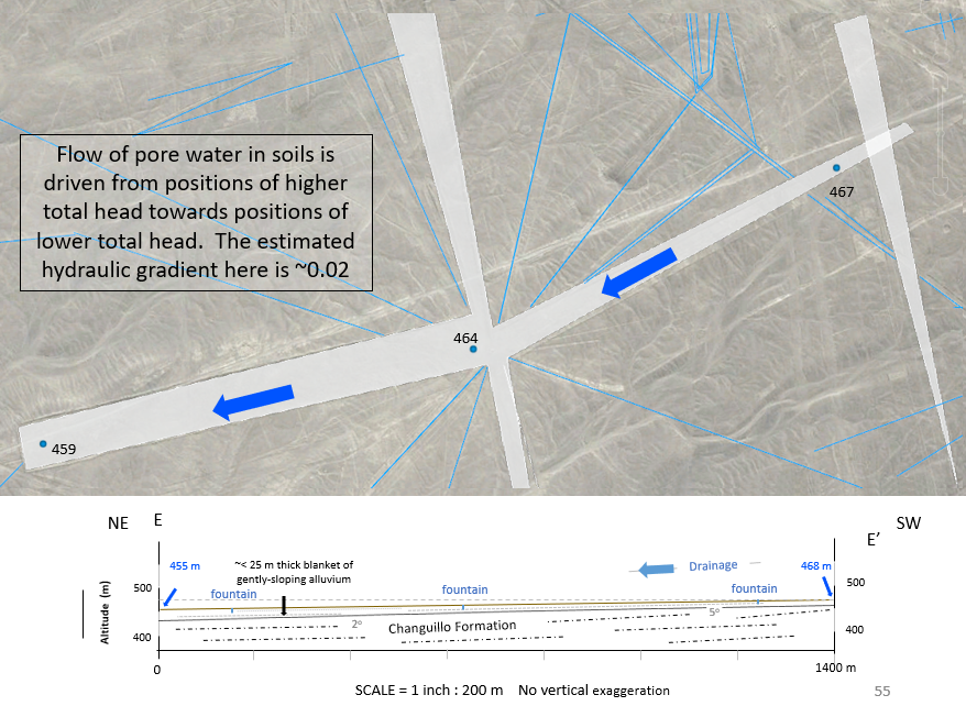
Figure 17.
Ancient water-resource engineering techniques were used
to short-circuit shallow-subsurface flow in alluvium to irrigate fields
and distribute water through trenched circuits from radial centers.
|

 TECTONICS BLOG
Rev. 2021-04-22; 2020-10-30
TECTONICS BLOG
Rev. 2021-04-22; 2020-10-30
Gregory Charles Herman,
PhD
Flemington, New Jersey, USA
The hydrogeological nature and
tectonic setting of the Nazca Lines
Introduction *
Nasca Culture * Tectonic Setting *
Methods * Nazca aquifer
* Summary *
References
Abstract
The original Nazca lines are a myriad of very old (~70 BCE – 700 CE), large geoglyphs
spread over 200,000 acres of the Peruvian pampas that are visible from the air
and adjacent mountains. The glyphs have spiral, zigzag, trapezoidal,
round, and quadrangular forms including large rectangular fields cut into pediment alluvium
atop plateaus and alluvial valleys at altitudes ranging between 400 to 1000 m elevation in
the Andes Rio Grande drainage. The highest concentration is located along the southern bank of Rio
Ingenio, a major, central tributary of the Rio Grande drainage. This marginal-marine
continental setting receives less than 1-inch of rain per year so that ground
disturbances are preserved. Surface alluvium weathers to a dark desert varnish
that lends stark contrast to uncovered, lighter substrate giving form to the
glyphs. The lines likely originated from human augmentation
of natural hydrogeological conditions to divert seasonal
water flowing down mountain streams into irrigated fields sitting atop a
perched aquifer with gently
tilted bedrock directing hydraulic flows. Seasonal runoff naturally flows
downhill to the area having the most glyphs where agricultural systems evolved from early paddies
having
zoomorphic and phytomorphic forms into subsequent, outlying, expansive fields with
trenched irrigation systems. The porous, unconsolidated, surficial materials of the
Nazca aquifer get seasonally recharged and gradually
discharged remotely along the plateau edges where springs were
first discovered, then engineered into sophisticated water-supply systems as
cultural centers arose.
The Nazca lines were developed to take advantage of natural hydraulic conditions
reflecting a unique structural setting caused by subduction of the Nazca ridge, a thickened
segment of oceanic crust that's being shoved beneath the South American margin at a speed of
~50-60 mm per year. The battering-ram effect arches overriding continental
crust upward into a structural culmination where the oldest bedrock is unroofed
along the convergent tectonic-plate boundary. The Rio Grande
drainage is developed on the eastern flank of this culmination and follows deeply rooted
faults that propagate landward and flower upward through the crust to form an
array of normal fault blocks stepping down from the culmination crest. Prior archaeological work and published geological data are
augmented with a remotely sensed structural hydrogeological framework to
exemplify how the Nazca aquifer was utilized over time. The framework was built
and rendered using Google Earth, QGIS, SketchUp Pro, and a 3-point
structural-plane solver programmed for use with NASA's WorldWind virtual Earth
globe. By identifying the hydrogeological nature of the lines, more recent, counterfeit ones can be discerned.
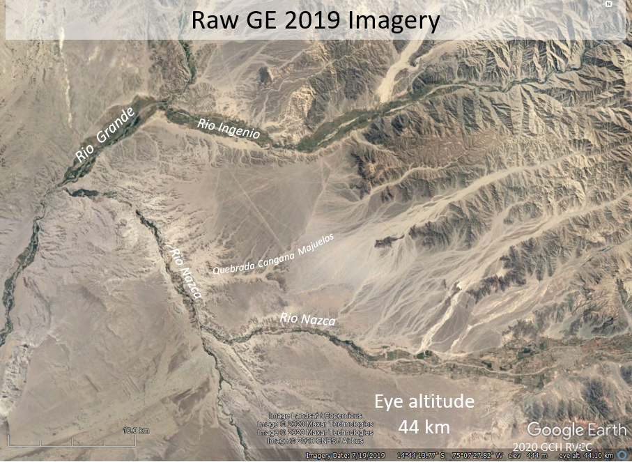
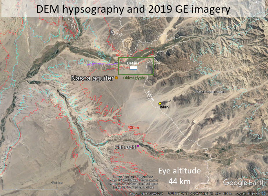
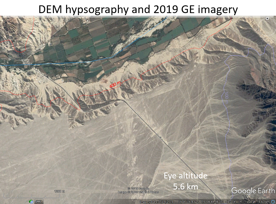
Introduction
The union of two
independent paths of geological research merged one day in 2019 with the result
being a discovery of how a unique tectonic setting gave rise to a unique human
culture at the dawn of the Common Era. The first path is
structural hydrogeological research being conducted on the Nazca
lines in central Peru that stems from exploring their nature beginning in 2013
during college
laboratory exercises using Google Earth (GE; figs. 1
to 4). The second path is the impact-tectonics work showcased in earlier
blog posts that led to the discovery of a suspected, large, Early Miocene (~
24 Ma) impact-cratering event that set the tectonic stage for the glyph
development (fig. 5 and table 1).
The bolide-impact fractured and thickened the Pacific lithosphere Eons ago
resulting in the Nazca Ridge, and subsequently the East-Pacific oceanic rise (fig. 5).
Ensuing, eastward tectonic-plate drift and subduction of the thickened Nazca Ridge
is preferentially raising the western continental margin into the Andes
Antiplano culmination (fig. 6). The Nazca lines were crafted on the eastern
flank of the culmination where
down-faulted blocks of gently titled strata are arranged to funnel mountain runoff into a desert aquifer (figs. 7 and 8). The
most dense occurrence of geoglyphs are etched into the
surface of the Nazca aquifer, a thin alluvial blanket resting on bedrock along the
northern edge of the pampas that is cut by the Rio Ingenio (figs. 1 to 3). This work
therefore portrays the tectonic setting of the central Andes Mountains of Peru
and bordering parts of the Eastern Pacific and the geological components of the
aquifer that provided ample
freshwater resources to sustain a growing population in a desert environment.
As a final point of introduction, archeologists and anthropologists refer to the culture as 'Nasca', but all
geographic names and places as well as geological feature, like the Nazca Ridge,
use the consonant "z" rather than "c". So in
accordance with my understanding of this dichotomy, I use both versions depending upon
whether the subject is animate or not. . .
The Nasca culture and freshwater
A thorough, modern treatment of the Nasca culture and their natural resources is
provided in a book by Lasaponara and others (2016a) titled "The Ancient Nasca
World". This work details over three decades of multidisciplinary Italian
research upon which this work principally uses when summarizing cultural traits
for geological comparison.
Other important works incorporated here include the work of Donald Proulx,
Professor of Anthropology Emeritus of the University of Massachusetts that
studies the Nasca for decades and maintains a
university web site detailing
associated aspects.
The Nasca culture stemmed from the Paracas culture, inland wayfarers traveling the Peruvian
coast along the
foot of the Andean
Mountains prior to the Common Era (fig. 5). At this time organized human societies were being established inland in semi-arid
lands where river resources provided
the freshwater needed to support rural agriculture and the organization of urban cultural hubs with monumental architecture, deity worship, and ritual sacrifice.
Much earlier, limited human occupation of the Nasca valley reaches far back as
4000 BCE in spatial association with
groundwater springs located at Cahuichi (fig. 3; Della Rose, 2019).
The Nazca lines likely originated from human
augmentation of natural hydraulic conditions that diverted spring runoff from
bordering mountains into agricultural gardens and fields sitting on a perched
aquifer underlying an expansive plateau in an arid coastal setting (figs. 2 and 7). Most of the geoglyphs are
probably water trenches, canals, and fields etched into alluvial terraces (fig.
1) draped atop gently tilted bedrock of intermediate igneous and volcanic
composition (figs. 9, 10, and 11). Exposed pebbles and cobbles at the top of the
alluvial blanket developed a dark, desert varnish after eons of weathering in an
arid, marginal-marine setting. The varnish is the oxidized coating of iron-rich
mafic rocks that lends stark contrast to unexposed, or in the case of the Nasca
lines, thousands-of years old excavated substrate formed of light-colored fine
sand to clay (fig. 11) giving visual contrast to the numerous geoglyphs cut into
the alluvium over time, and observable from mountain elevations, aerial flights
and remote sensing (figs. 3 and 4)
The Nasca
architecture, graves, and iconography
conveyed on
pottery and in textiles are arranged
by archeologists
into early (proliferous ~70 BCE - 200 CE), middle (transitional ~200-400 CE ), and late (monumental ~400-700
CE) thematic stages (fig. 12).
These stylistic, iconic depictions of an antiquated culture only convey so much information, so
the cultural significance and meaning of the Nasca lines have been
a matter of considerable study, analysis, and debate since the 1940s, with the area
being designated a United
Nations World Heritage Site in 1994. The lines have been
measured and categorized in great detail including their lengths, widths,
geometric arrangements, and intriguing zoomorphic (animal), phytomorphic (plant), and anthropogenic forms (figs.
3 and 4).
Early archeological work on
the lines by Xesspe Mejia in 1942 noted the
linear similarity between the glyphs, water channels, and aqueducts that tapped
the water table. Many other, similar
associations have followed that demonstrate the lines definitive link with water,
irrigation, and agriculture.
Potsherds
litter the terrain and are incorporated into earthen mounds leading researchers like
Silverman and Proulx (2002) to associate the lines with
water-related ceremonial paths through irrigation networks reflecting social space.
A detailed
hydrologic
study of the Nazca area was conducted
by the University of Massachusetts geologists in the 1990s in association with
David Johnson (1999). That work also noted the association of the lines with
aqueducts and concealed faults that channel
groundwater flow.
The Nasca flourished during a time when
global climate temperatures were a few degrees Centigrade cooler than now and consistent
through a 700-year period before the
onset of a series of droughts that preceded a 500-year slide into an anomalously
chilly time known as the little ice age (fig. 12).
Close scrutiny of geological cores taken from Holocene Andean glaciers and
nearby lakes show that dust storms peaked
around 600 CE (Thompson
and others, 1985)
within a 190-year prolonged drought (~540 - 730 CE; Lasaponaro and others, 2015).
This climate shift shrank water availability that most likely led to
societal fragmentation, collapse, and redefinition.
Precipitation levels
during the Nasca period were more than now because the
riverine oases and river dwellings of current inhabitants are focused in valley
floors whereas many abandoned Nasca villages and earthworks extend upslope as
much as 200 m. Springs rains that now provide vital
resources for current river dwellers must have run harder and longer to
charge the paddies, terraces, and ponds crafted at the higher elevations.
Based on
prior work, and with augmentation of new geological details here,
the sequence of glyph development
is congruent with the three societal stages defined by their ceramic and textile iconography
(figs. 12 and 13), and
the discovery of freshwater springs in the
Nazca region subsequently led
to ancient water-resource engineering practices that fashioned the
landscape as part of the resulting societal footprint. The various landscape
elements reflect cultural evolution from early coastal ties that shaped naturalistic
motifs through subsequent agrarian
and militaristic societal stages concluding with polygonal
agricultural fields extended
over roughly five times the area of that where the earliest glyphs are focused (figs. 1, 10 and 11).
Lasaponaro and others (2016) note the steady advance of the populations up stream
in different valleys to tap groundwater reserves in addition
to earlier efforts on the pampas focused on harnessing spring runoff from the
mountains. It is unclear exactly when the Nasca developed aquifer-management
methods, but the demands that water scarcity placed on a burgeoning population
must have spurred ingenuity in both the manner in which freshwater was accessed
and managed that influenced population volume.
Mapping Methods and Tectonic Setting
I was introduced
to the Nazca lines as a teen in the 1970s
from reading von Daniken’s (1969) Chariots of Fire. Because of their unique,
curious nature, I decided to use them decades later as a prop for teaching
college-level physical geology laboratories designed to learn GE. During this
time I began mapping the Nazca regional geology using GE to characterize the
tectonic setting by adding published geospatial themes for the area and compiling new ones
(figs. 5 to 8). The latter includes a detailed structural analysis of stratigraphic layering in fault blocks
(fig. 8)that relied upon a custom
geology tool
developed at the New Jersey Geological & Water Survey (NJGWS)
in 2014. This tool uses NASA's WorldWind
virtual Earth globe to pinpoint three places along traces of geological planes
seen on bare ground in aerial imagery, then extracts their spatial coordinates
from the globes digital-elevation model (DEM) to calculate the 3D plane dip and
dip azimuth. Multiple oriented planes are generated within an analysis
session and saved as data files that are compatible for input into GE as 3D
object models.
The Nazca geoglyphs are visible on the Peruvian coast in GE at 50 km eye altitude and become clearer when viewed even closer to ground surface (figs. 1
to 4, 14 and 16 to 17).
This study was conducted by highlighting places and features in GE using vector and raster data in the form of
placemarks, polylines, polygons, custom imagery, and embedded symbols with notation.
GE is a versatile platform that can be used to place features in a geospatial perspective to
facilitate the geological analysis of an area like this and resulting in this hypothesis
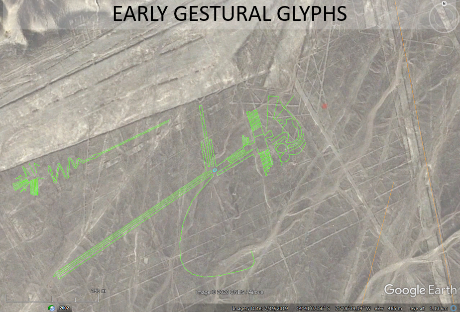
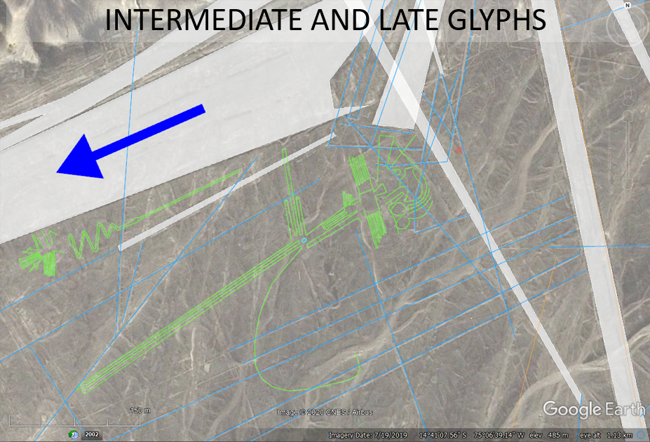
based-on remotely sensed geospatial information. Nazca geoglyphs on the pampas were constructed with hydrologic, flow-through designs
that were developed in a manner that first captured natural seeps, then later incorporate
more-widespread water-diversion schemes that directed
seasonal runoff into fields and aquifer-recharge portals that promoted freshwater
discharge into the campo barridas for prolonged periods afterwards
(figs. 14, 16 and 17).
Recognition of their hydraulic nature
helped decipher their relative timing of development
that is primarily based on geological cross-cutting
relationships (fig. 14). The evolution and complexity of the glyphs through time
represent landforms made by an early, expressionistic,
sea-faring culture that subsequently evolved into agrarian and concluding
militaristic ones. But other, newer glyphs occur among the
ancient ones, and apparent counterfeit ones can be discerned when considering
the hydraulic designs having 'open' forms versus 'closed' forms.
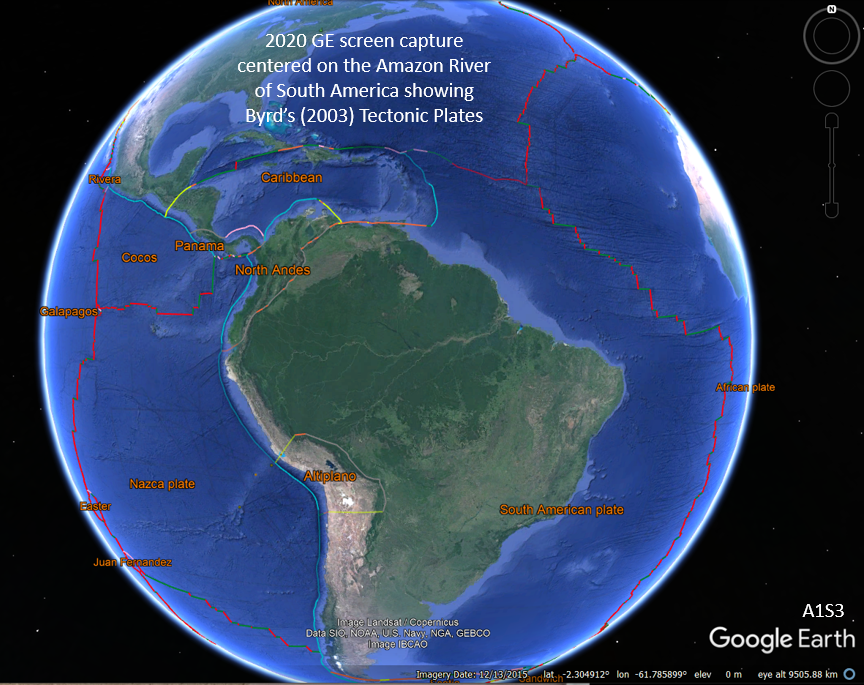
The Nazca tectonic plate is currently drifting eastward at less that 70 mm year where it
has been colliding with and shoved beneath the western continental margin of South America for at least the past 24 Ma (fig. 5 to 7). The comparatively thicker and less-dense continental crust of the South American plate is lifted by
thermal and isostatic effects as the oceanic lithosphere
is subducted and assimilated into Earth's upper mantle (fig. 6). Regional directions of plate drift differ slightly between the Nasca and South American plates, with the latter having northerly trends in the continental interior (fig. 5).
The Nazca lines are located along the continental margin where the Nazca Ridge
is being subducted as part of the Nazca plate. The Nazca Ridge is one of a set of thickened, linear oceanic segments
radiating outward from the center of the
Nazca Plate from a disrupted region where secondary fracturing and magmatism appear to
stem from a bolide-impact event, with a central crater herein named the Nazca crater (fig. 5).
The suspected Nazca impact event was discovered while using GE to examine the regional tectonic setting. This
event awaits scholarly confirmation, but appears to have been a shower of
bolides or a fragmented, larger one of uncertain composition because of the many circular depressions
lying amid a set of linear, ocean-floor fractures along a 390o heading (fig. 5). This set
of fractures compliments others where secondary magmatism has risen and thickened the oceanic
crust in a region covering almost one-half million square kilometers relative to undisturbed, or 'normal' oceanic crust (fig. 5). The main crater lying at the
center of this strain field is about 85 km in diameter (table 1, fig. 5). The bolide impact heading is assumed to parallel the
390o fracture set that shows symmetric alignment with ocean-spreading ridges,
aseismic ridges, and other structural lineation mapped on the sea floor (fig. 5). The same set of far-field lithospheric welts surrounding this
impact
center as seen elsewhere including a major lithosphere arch located at about
2900 kilometers radial distance that directly corresponds with major segments of the East Pacific Rise! This
agrees with prior observations that
impact-tectonic strains can form tectonic-plate boundaries and influence
subsequent movements including far-field crustal welting around large craters
reaching distances of at least 2900 km (Herman, 2005). Deep-sea core 1237A provides a good indication of the
timing of the event, as major sea-level and sedimentation changes occurred in the area at about 24 Ma (fig. 15). The tectonic setting defines the unique geological architecture of this area because it is the only place along the convergent tectonic margin where the thickest and most extensive oceanic ridge in the region is being forcefully inserted beneath the continental margin
to raise the Andes Antiplano (fig. 6).
The physiographic expression of the Rio Grande drainage resembles a candelabra with a seaward base that branches symmetrically
outward on both sides of the Rio Grande at the depresión de Ica-Nasca (fig. 7). The major tributaries of the Rio Grande probably follow deeply-penetrating fault systems along which surface water preferentially
incises. It is difficult to prove this without direct subsurface evidence, but surface drainages normally follow dense fracture
systems in general, and are portrayed as such here.
Because of the unique tectonic setting of the Rio
Grande drainage, strata generally dip toward the central tributaries, thus directing surface and
shallow subsurface water
downhill to the area where the earliest Nazca lines were first crafted
(figs. 7 and 8). The oldest, most naturalistic glyphs are focused high on the southern
bank of the Rio Ingenio where natural seeps occurred from the edge of a perched,
pampas aquifer, and where the early Nasca first impounded seasonal runoff for
growing crops (figs. 1 to 3).
Nasca Aquifer
The Nazca aquifer is comprised of Quaternary alluvium draped upon of gently tilted, fractured, faulted, and warped
Tertiary and younger bedrock (figs. 7 to 12). The hydrogeological framework
therefore has both surficial and bedrock
components with bedded strata overprinted by secondary and compound tectonic structures.
Detailed stratigraphic aspects of the area are based on
prior map and detailed geological studies (Wetzell
and Matos, 2003; fig. 10, and Delle Rose and others 2019; fig. 9)
but the structural controls on the conceptual
aquifer model were derived from using the aforementioned
WorldWind
virtual-mapping application (fig. 8).
The regional geological cross sections show that the
physiographic feature named depresión de Ica-Nasca defines the
southwest limit of the Nazca lines because it is the keel of a structural
synclinorium between strata dipping
seaward off flanking mountains (fig. 9) with a high groundwater-recharge potential as opposed to shoreward strata
that dip inland, lack the recharge potential, and is therefore a comparatively
poor aquifer. But the Nazca lines rest on the northeast limb of the syncline
also because thick alluvial fans emerge from mountain passes that mantle fractured bedrock and
become seasonally saturated (fig. 8).
The porous, unconsolidated, surficial materials of the
Nazca aquifer therefore get seasonally recharged from the mountain runoff that
also infiltrates
into underlying fractured bedrock strata of the Tertiary Changuillo Formation
(fig. 9). Seepage discharges
along the
riverbanks and plateau edges occurs from both surficial and fractured bedrock
lying directly above modern, active aqueducts (figs. 1 and 2). Bedrock strata are
gently tilted in adjacent fault blocks that
weather deeply along fault systems that surface-drainage systems follow and and
provide aquifer recharge (fig.
8). The Nazca aquifer was likely discovered along the Eastern bank of the Rio
Ingenio where natural freshwater springs seeps from a perched aquifer provided a
desert oases that was subsequently groomed and managed to feed water into
localized gardens and
agricultural plots before more expansive, cultivated
fields were developed to meet the needs of a growing theocratic society. But the reason that the freshwater resources are located
there is because this
tectonic setting is unique along the entire length of the South American Andes
Mountains. The
battering-ram effect from inserting a thickened section of oceanic crust beneath
the
continental margin results in the overriding crust arching upward into a a
structural culmination where the oldest bedrock is exposed at ground surface along the western
side of the South American continent (fig. 2).
The Rio Grande and tributaries follow emergent,
but concealed normal faults
that branch upward and landward from deeply rooted faults situated on
the eastern flank of the Andes structural culmination (figs. 6 and 7).
Summary
This hydrogeological interpretation of the Nasca
lines relies principally on the fact that water runs downhill under the
influence of gravity, and the relative timing of geological features can be
assessed by observing cross-cutting relationships; one of the
fundamental principles of historical geology.
By employing these two principles and adding
structural-geological and spot elevations, it is hypothesized that the Nasca lines evolved through time
at a location where original wayfarers discovered freshwater springs seeping
from a perched aquifer in a desert. The precious water was first ponded into
small garden plots having naturalistic, expressionistic motifs and
open-hydraulic designs that allowed water to accumulate but flow sluggishly
through without stagnation. Subsequent water-engineering methods were developed
though creative development and implementation of early, effective engineering
of water-management schemes including surface-water diversion mains and shallow
subsurface aquifer components associated with the myriad paths and fields that
are now littered with broken fragments of
ceramic ,
water-bearing vessels (potsherds). The large fields have varying degrees of interconnectedness and
are clearly seen overprinting the earlier naturalistic glyph forms, although it also
apparent that some of the older, more intricate glyphs have been spared
destructive overworking by successive generations in probably reverence of
ancestral works, or perhaps because they were efficient and sustainable through
the successive generations and cultural adaptions.
To conclude, by integrating published data, virtually compiling and mapping structural
aspects of the drainage, and from adding spot elevation at intersecting lines, the hydrogeological controls on the
pampas Nazca lines become clear and are shown
above to be systematic with respect to water running downhill.
The uniqueness of this site along the Andes Mountain
chain reflects the specific arrangement of
geologic strata that naturally funnel, store, and discharge surface and shallow
groundwater into springs and riverbank seeps that were discovered then augmented to supply desert
fields with the precious water needed to sustain a growing, pre-historic
culture.
The complex patchwork of features reflects their temporal societal evolution
controlled by the local geological setting and climatic fluctuations that helps
explain the enigmatic Nazca lines.
References
Caldas, J. V., Montaya,
M. R., and Garda, W. M., 1981, Mapa Geologico del cuadrangulo De Palpa:
República Del Perú, Instituto Geologico Minero y Metalúrgico, Escala 1:100,000
Delle Rose, M., Mattioli,
M., Capuano, N., Renzulli, A., 2019, Stratigraphy, Petrography and Grain-Size
Distribution of Sedimentary Lithologies at Cahuachi (South Peru): ENSO-Related
Deposits or a Common Regional Succession? Geosciences, vol. 9, 18 p.
2006 Herman, G. C., Neotectonic
setting of the North American Plate in relation to the Chicxulub impact:
Geological Society America Abstracts with Programs, Vol. 38, No. 7, p. 415 (1.3
MB PDF file)
Johnson, David, 1999, Die
Nasca-Linien als Markierungen fur unterirdische Wasservorkommen. Nasca:
Geheimnisvolle Zeichen im Alten Peru, ed. Judith Rickenback, p. 157-164: Museum
Rietberg Zurich, Switzerland.
Lasaponara, R.,Rojas, J. L.,
and Masini, N., 2016, Puquios: The Nasca response to water shortage,
in Losaponara, R,
Masini, N, and Orefici, G., eds., The Ancient Nasca World: Springer
International Publishing, Switzerland, p. 279-327
Lasaponara, R.,Masini, N,
and Orefici, G., editors, 2016, The Ancient Nasca World, Springer International
Publishing, Switzerland, 670 p.
Masini N. and Orefici G.,
2016. Cahuachi and Pampa de Atarco: Towards Greater Comprehension
of Nasca Geoglyphs, in Lasaponara R., Masini N., Orefici G., eds., The
Ancient Nasca World New Insights from Science and Archaeology: Springer
International Publishing, p. 239–278, doi: 10.1007/978-3-319-47052-8_12
Mix, A.C., Tiedemann, R.,
Blum, P., 2003, Proceedings of the Ocean Drilling Program, Initial Reports
Volume 202, Chapter 7, 74 p.
Orifici, Giuseppe, 2016a, Nasca historical and cultural analysis, in Losaponara, R,
Masini, N, and Orefici, G., eds., The Ancient Nasca World: Springer
International Publishing, Switzerland, p. 65-86.
Orifici, Giuseppe, 2016b,
The ceremonial center of Cahuachi: Its origins and evolution, in Losaponara, R,
Masini, N, and Orefici, G., eds., The Ancient Nasca World: Springer
International Publishing, Switzerland, p. 329-342.
Orifici,
Masini, N., and Lasaponara, R., 2016c, Thirty years of investigations in Nasca:
From Proyecto Nasca to the IRACA Mission: in Losaponara, R,
Masini, N, and Orefici, G., eds., The Ancient Nasca World: Springer
International Publishing, Switzerland, p. 1-20.
Rodbell,
D. T., Smith, J. A., and Mark, B. G., 2009, Glaciation in the Andes
during the Late glacial and Holocene, Quaternary Science Reviews, Volume 28,
Issues 21–22, p. 2165-2212.
Silverman, H. and
Proulx, D., 2002, The Peoples of the America, The Nasca: Blackwell Publishers,
Maiden, Ma, USA, 339 p.
Thompson, L. G., Davis,
M. E., Mosley-Thompson, E., and Liu, K-b., 1988, Pre-Incan agricultural activity
recorded in dust layers in two tropical ice cores: Nature, v. 336, p. 22-29.
Wetzell, Julio and Matos,
Orlando, 2003, Memoria descriptive de la revisión Y actualización del
cuadrángulo de Nasca (30-n): República Del Perú, Instituto Geologico Minero y
Metalúrgico, Escala 1:100,000
von Däniken, Kurt, 1970,
Chariots of the Gods: The Berkeley Publishing Group; Penguin Group, New York,
NY, 163 p
Abstract * Introduction *
Nasca Culture * Tectonic Setting *
Methods * Nazca aquifer
* Summary *
References
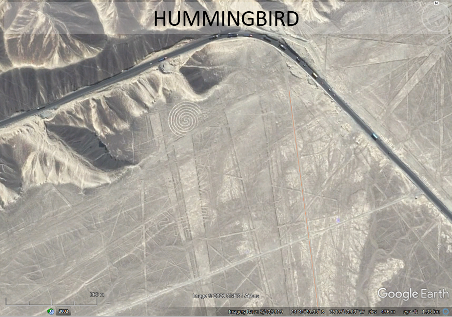
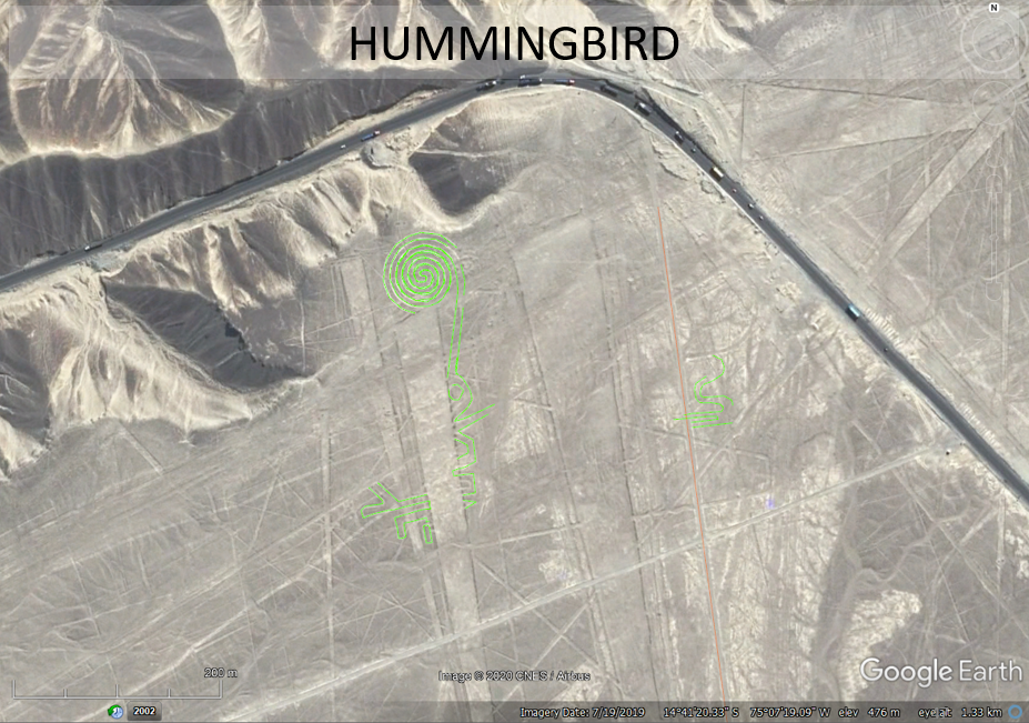
Impacttectonics.org
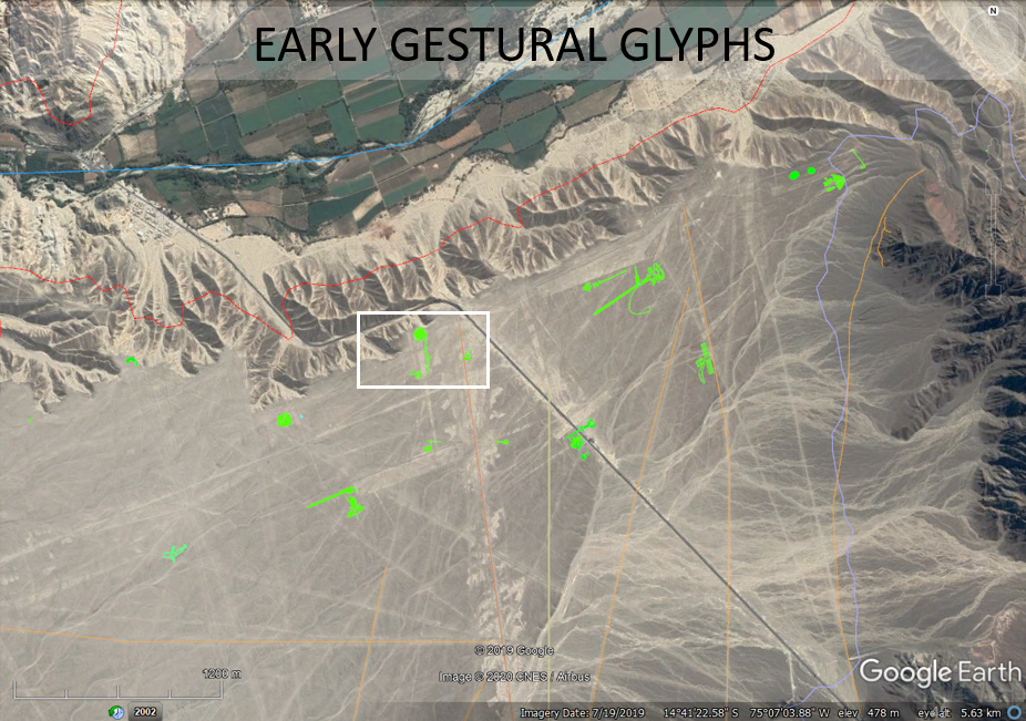 Figure
3. Nazca physiography, hydrography, and
early geoglyphs as seen on 2019 GE imagery.
Figure
3. Nazca physiography, hydrography, and
early geoglyphs as seen on 2019 GE imagery.
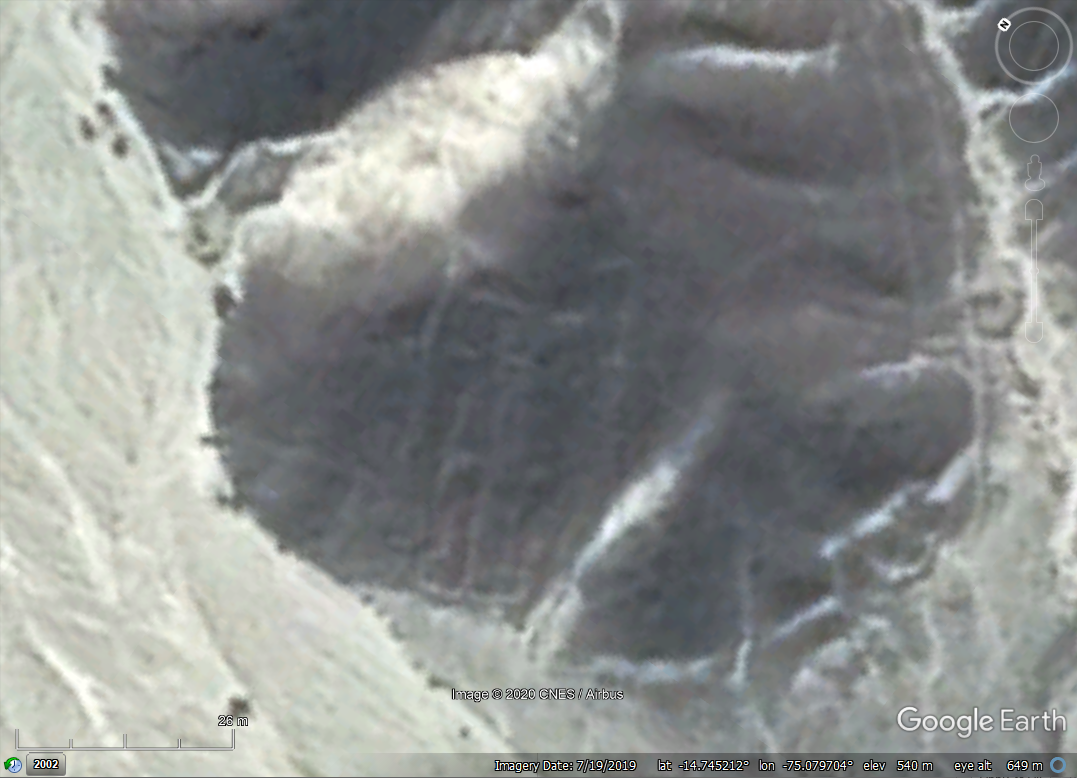
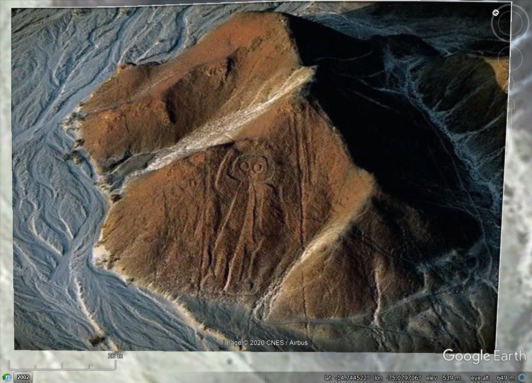
 Figure
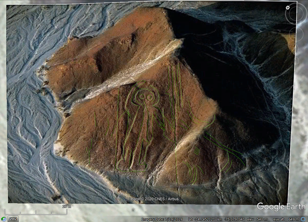
4. A renowned anthropomorphic Nazca geoglyph is carved into a
hillside above the pampas and has no apparent water-related utility. An internet
search for aerial photos of this feature includes one shown below that
was added to GE for an enhanced display of its details.
Figure
4. A renowned anthropomorphic Nazca geoglyph is carved into a
hillside above the pampas and has no apparent water-related utility. An internet
search for aerial photos of this feature includes one shown below that
was added to GE for an enhanced display of its details.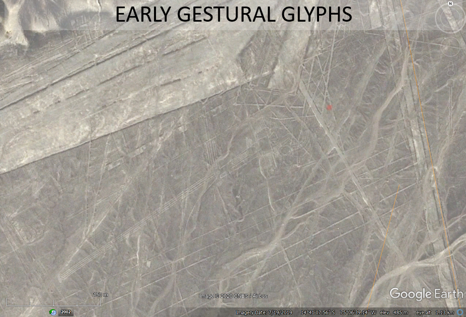