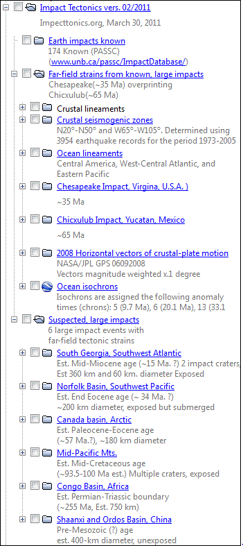
 Explanation Explanation
The Impact Tectonic
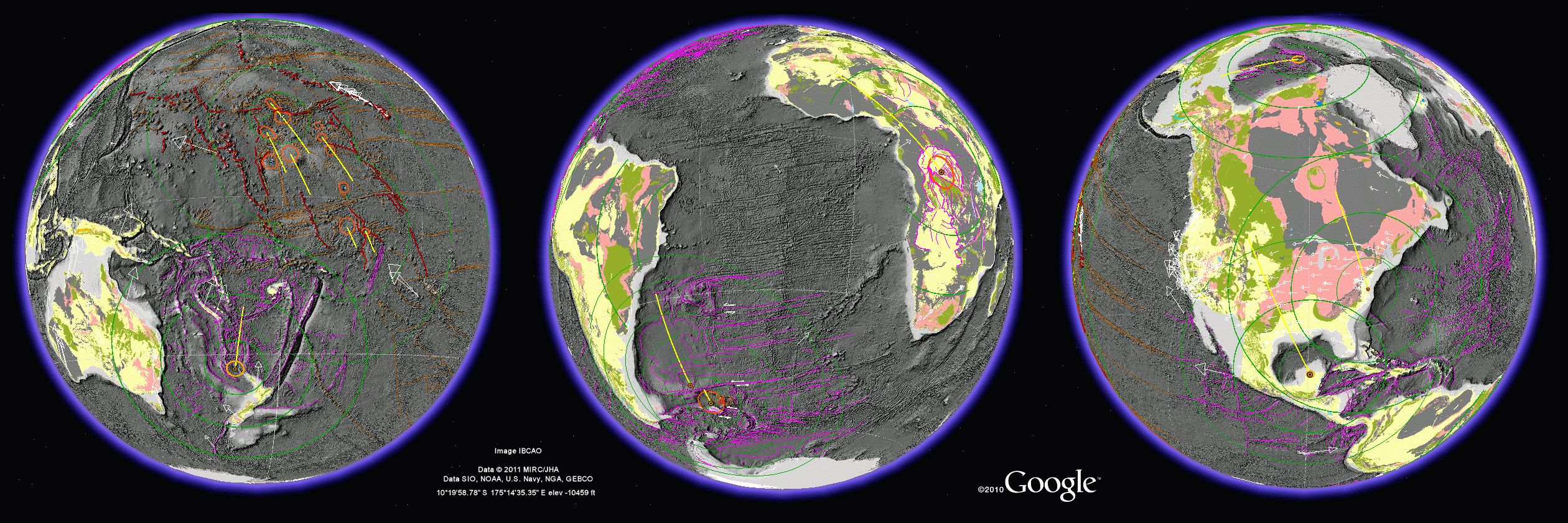
Google Earth (GE) ver. 082011 KMZ application shows strain effects
from two known and six suspected large-bolide impacts on Earth, spanning
Paleozoic to Tertiary
ages.
These large impact are thought to perturb, and possibly
help drive tectonic-plate motions.
Each
folder in
the KMZ file contains line paths tracing crustal features representing impact
strains. Far-field body strains in the crust and mantle include
circumferential crustal welts and seismic zones, foreland shear fractures
and thrust-faults, and hinterland extension fractures and normal faults that
are systematically distributed about craters. The crustal compression path
for each impact event is represented as a line extending from the center
of a crater into the foreland along a path of crustal compression that is
parallel to the bolide-descent trajectory.
Circumferential rings of ~660, ~1700
and ~2900 km radii are drawn around most craters. These circles trace
circumferential arches, troughs and seismic zones that define impact-generated
crustal welts. Many of these impact events are single impacts. However, the
Mid-Pacific Mountains probably involved multiple strikes in an enormous strewn
field. The South Georgia impact may have
been a one-two punch, perhaps
involving a secondary strike from a spalled fragment off the main
bolide. Crustal strain features
were mapped using Lambert equal-area, azimuthal projections using a geographic
information system. These projections are centered on craters and were projected
into geographic space for display in GE. Each site is named and includes
an estimated age of each event based on nearby stratigraphic relationships,
volcanic activity, and ocean-crust drilling records from the deep-sea
(DSDP) and ocean-drilling
(ODP)
projects.
Line paths
of ocean-floor isochrons (Müller and others, 1997,
2008) are included
for age reference.
Other shapes
include vectors of the
horizontal component of tectonic-plate motion
(mm/yr velocity) from global, ground-based GPS stations
(NASA JPL). Vector
sizing is based on multiplying the velocity value by 0.1 degree for display
in geographic space.
A
comprehensive impact database for Earth is included that was produced by
S.
Levesque and available through the
Google
Earth Community. For further information see
Far-Field
Bolide-Impact Strains on
Earth.
References
Müller, R.D.,
Roest, W.R., Royer, J.-Y., Gahagan, L.M. and Sclater, J.G., 1997. Digital
isochrons of the world's ocean floor. Journal of Geophysical Research, 102:
3211-3214.
o GE
Müller, R.D.,
Sdrolias, M., Gaina, C. and Roest, W.R., 2008. Age, spreading rates and spreading
asymmetry of the world's ocean crust. Geochem. Geophys. Geosyst., 9(Q04006):
doi:10.1029/2007GC001743. |
|