![]() Impact Tectonics Google Earth ver. 0110
Impact Tectonics Google Earth ver. 0110
A set of line shapes generated using geographic information systems that are imported into Google Earth (GE) and combined with GE paths, to show hypothetical crustal strains stemming from known and suspected, hypervelocity, large-bolide impacts on Earth.
Download Google Earth ImpactTectonics v. 1109.kmz file (835 KB) .
The data files listed below are combined into a Google Earth KMZ application
to show spatial relationships between two known and six suspected
bolide-impact events on Earth and associated, hypothetical, far-field crustal
strains. These strains include regional, circumferential crustal welts and
seismic zones, foreland fracturing and thrust-faulting ,and hinterland
extensional fracturing and faulting around each impact crater. Crustal
strains are systematically distributed about each impact crater, with primary
compression paths for each event shown as lines extending from the center
of each crater into the foreland regions along paths that parallel the descent
trajectories of each oblique impact. Impact strains are portrayed as perturbing,
and possibly driving tectonic-plates motion. For further explanation of each
event and associated crustal and mantle strains please see
Far-field bolide-impact strains on
Earth![]() .
.
 |
|
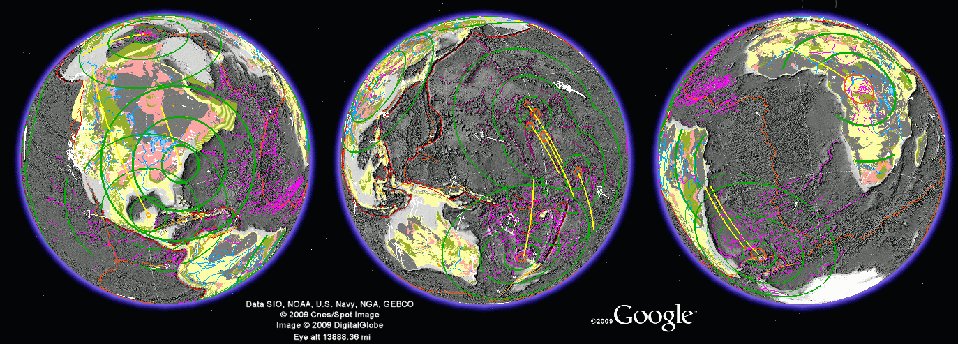
| Three views of Earth showing hypothetical far-field impact
strains with respect to two known and five suspected impact events. Far-field strains include impact-generated crustal welts and troughs that are circumferential to impact craters, and crustal fractures and faults possibly stemming from impact stresses. Also shown are plate-motion vectors generated using 13 years of GPS-based plate-motion data and lines drawn parallel to bolide-decent paths from the impact point towards foreland-directed strains. Also shown are grayshade sea-floor physiography and continental crustal ages, color-coded by geologic Era. Line shapes included in the KMZ file: ESRI World rivers - Major rivers from ESRI. UT Tectonic-plate boundaries - Line shapes of tectonic-plate boundaries from the University of Texas PLATES project. These include traces of transform faults, sea-floor-spreading ridges, and subduction trenches. Tectonic-plate-motion vectors - NASA JPL horizontal component of tectonic-plate motion extracted from global, ground-based GPS stations. Line vectors were generated using an ESRI ArcView extension to produce magnitude-weighted vectors of the horizontal component of plate motion including azimuth direction and velocity (mm/yr). Vector sizing is based on multiplying horizontal velocities by 0.1 degree for display in geographic space. Folder Earth impact craters - 174 known and 11 suspected impact craters. 1) The known craters are cataloged by PASSC. Listed crater locations and sizes were used to generate circular buffers around impact points using crater center ponts and radii. Please note that craters appear elliptical at higher latitudes due to the lateral stretching of geographic space. Features attributes are modified from the PASSC database for display in Google Earth.
2)
Folder
!! Warning. This KMZ application can crash a computer with less than 1 GB RAM. Be careful not to have all layers active at once if you have less than 1 GB RAM.
|